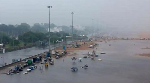
Cyclone developing in Bay of Bengal to bring heavy rains to southern states: IMD
Mangalore Today News Network
Chennai, Dec 01, 2020: Parts of Tamil Nadu, Kerala, Puducherry, and south coastal Andhra Pradesh will start receiving heavy rainfall under the influence of a deep depression in the Bay of Bengal. The low pressure system is likely to intensify into cyclone with wind speeds of up to 80km per hour by Tuesday evening and will be named Burevi.

The system is currently located 930km southeast of Kanyakumari. As per the current trajectory, the India Meteorological Department (IMD) has forecast that the cyclone will continue to move northwestwards and cross the Sri Lankan coast near Trincomalee in the evening or night of December 2. It is likely to continue its westward movement to reach the Indian coast the next morning.
The cyclone comes on the tail of the severe cyclonic storm Nivar that had made landfall in Karaikal, Puducherry, on November 25. It was the third named cyclone to hit the Indian coast in 2020 -- the first was super cyclonic storm Amphan in May and severe cyclonic storm Nisarga in June.
There would be squally winds reaching the speed of up to 65 km per hour on Tamil Nadu and Kerala coast on December 2 as the system nears India.
As per the IMD forecast, it is likely to bring extremely heavy rainfall to parts of south Tamil Nadu and south Kerala on December 3 when it is likely to reach the Indian coast.
The sea conditions will be rough to very rough Monday through December 4, with the government advising a complete suspension of fishing operations in the region. The fishermen have been advised to return to coast by Monday.
Courtesy:Hindustan Times
- ’Kodial Theru’ -Mangaluru Car Festival concludes with colourful okuli
- Shirva: Tipper driver dies after vehicle collides with car
- Minister Dinesh Gundurao inspects Addoor-Polali bridge works
- Kadaba: Rider injured as tree falls over moving bike
- Mangaluru: Grand ’Kodial Theru’ celebrated at Sri Venkataramana Temple
- Uppinangady: Timber mill gutted in accidental fire
- Changes in train services to fecilitate track maintenance works in the Palakkad Division
- Sangeet Bharati Foundation, Mangaluru is to organize national level youth festival
- Puttur: Rider dies in bike-autorickshaw collision
- Residents demand KSRTC services between Kundapura-Nada and surrounding villages
- Congress leader Chittaranjan Shetty injured after pistol misfires in Mangaluru
- Controversy erupts over demolition of rented house on Temple land; Complaint filed against MLA Ashok Kumar Rai
- Microfin ordinance proposes up to 10-year jail for violation, GUV nod pending
- Delhi Assembly Polls 2025: 46.55% voter turnout recorded till 3 pm
- Plane carrying 104 deported Indians from US lands in Amritsar
- Centre asks employees to avoid AI tools like ChatGPT, DeepSeek: Report
- PM Modi takes holy dip in Triveni Sangam at Maha Kumbh
- Iran is secretly developing nuclear missiles capable of hitting Europe: Report
- Ratan Tata’s aide Shantanu Naidu gets top role at Tata Motors: It comes full circle
- Rs 11 crore cash, 52 kg gold: Madhya Pradesh’s ’golden mystery’ unsolved
- Video: Rahul Dravid car collides with auto in Bengaluru, then a heated argument
- US C-17 military plane carrying 205 deported Indians to land in Amritsar in afternoon
- 16 Indian workers trapped in Libyan cement factory set to return today
- Not very big: Hema Malini shocker on Kumbh stampede that killed 30
- Kerala ’survives’ only with assistance from Centre, says Union Minister George Kurian
- Sandhya Shenoy honored with Society for Materials Chemistry Medal-2024
- White Cornus Apartment in Mangaluru
- City girl wins first place in state-level spell bee competition
- Alleged ‘Love Jihad’ Case in Mangaluru: Woman left home voluntarily, says police
- Girl fatally struck by reckless two-wheeler near Belman
- New residential complex for the judges inaugurated in Mangaluru
- Absconding accused nabbed after 8 years
- Truck with cylinders turns turtle in Beltangady
- Bhoota Kola artist dies of cardiac arrest
- Development of the country should be our goal: Ganesh Karnik
- Container truck gets stuck under Modankap railway bridge
- Truck crushes bike’s pillion rider near BC Road
- Head constable dies of heart attack
- Udupi: PDO dismissed over financial irregularities
- CREDAI to resume Skill Development Program for Construction Workers in Mangaluru
- CITY INFORMATION
- TRAVEL
- TOURIST INFORMATION
- HEALTH CARE
- MISCELLANEOUS


 Write Comment
 E-Mail To a Friend
 Facebook
 Twitter
  Print
Print 


